
The people's voice of reason
The people's voice of reason
This is an open message to all archaeologists in and around Alabama, and especially those who work or are interested in southwest Alabama.
Because of COVID-19 and intense campaigning in our last presidential and congressional elections, almost nobody noticed that an important historical milestone is about to arrive: From this past October 18, we now have less than 20 years to prepare for the 500th anniversary of one of Alabama’s greatest historical events—Hernando de Soto’s great battle at Mauvila. At this place, 82 Spaniards and as many as 11,000 Native Americans died from battle, injuries, disease, and being burned alive.
Some historians have described Mauvila’s location as the Holy Grail of the Soto expedition, but so far, nobody has yet discovered the site. And now, as this important anniversary approaches, current archaeologists seem to show no interest.
In the 1930s, the United States De Soto Expedition Commission was founded to trace Soto’s route and placed Mauvila’s most likely position in the vicinity of Choctaw Lake in Clarke County. Some villages and other remains have been found in this vicinity, but nothing that could be identified as Mauvila’s massive stockade.
Historical documents to determine the location have been few. Furthermore, some history books have added false and misleading notations about the Soto expedition.
We have only four original Spanish documents to describe it with any accuracy. Their four writers were Rodrigo Rangel, The Gentleman from Elvas, Luys Hernandez de Biedma, and Garcilaso de la Vega.
In 1983, Charles Hudson and his associates were able to accurately locate Chiaha and soon afterwards, Coosa.
In 1993, The University of Alabama published complete translations of the four original Spanish documents. These have proven to be very useful in providing accurate details of the expedition.
During this time, I have had many discussions with Mobile historian Jay Higginbotham about Mauvila’s location. From Hudson’s position of Coosa, over a period of several years, I traced Soto’s route down to Mauvila by matching the historical descriptions with the landforms. For details, refer to the e-book, “The Road to Mauvila,” which is available on Amazon.
From Coosa (9Mu102), Soto followed the Coosawattee and Oostanaula Rivers down to Itaba (9Fl162) at the junction of the Etowah River in what is now Rome, Georgia. Because of heavy rains, he was detained for eight days while waiting for the river to recede. Soto crossed the Etowah River and followed the east side of the Coosa River through Ulibahali (9Fl15), Apica (1Ce309), Piachi (near Hokes Bluff or site 1Et19 near Wharton’s Bend), Tuasi (near Lincoln or Ogletree Island), through uninhabited lands, “an old town that had double walls (at or near Hatchet Creek), a new village (junction of the Coosa River and Sofkahatchee Creek), through what is now Wetumpka, and stopped at Talisi, the southern extremity of the province of Coosa.
Elvas said, “The town was large and was located near a deep river. On the other side of the river were other towns and many fields of maize. On both sides, it was a land very well supplied with maize in abundance.”
Garcilaso de la Vega said Talisi was the last settlement in the province of Coosa “and therefore its frontier and defense. This town was exceedingly well fortified.... It had a rampart of wood and earth, [and] a great river almost completely encircled it and thereby made of it a peninsula.”
There can be no argument regarding the location of Talisi. It was on Parker Island (which was then a peninsula), the only landform within many miles that could be “almost completely encircled” by rivers. For miles, the surrounding land is rich and fertile just like the chroniclers described. Further proof is that when Soto’s men left Talisi, they immediately crossed “the River of Talisi” (the Tallapoosa) on rafts and canoes.
Talisi was most likely near the original junction of the Coosa and Tallapoosa Rivers. A spot of about 10 acres of 160 feet elevation and ideal for a village lies a quarter mile north of this junction and next to a slough which would have been perfect for a canoe harbor. The probability of Talisi being here is very high—perhaps close to certain, considering the lack of well-suited sites nearby. Archaeologists should get out their LIDAR and ground penetrating radar and scan it thoroughly.
From Talisi, Soto crossed the Tallapoosa River, passed through downtown Montgomery and on into Casiste (1Mt51), Caxa (possibly 1Lo38) on the river not far from Whitehall, and camped next to the river across from Humati (1Ds32) on the other side of the river, where Cahaba was later built. From there, he went through Uxapita (1Wx1), camped in the open, and met Tascalusa at Athahachi (1Mn67).
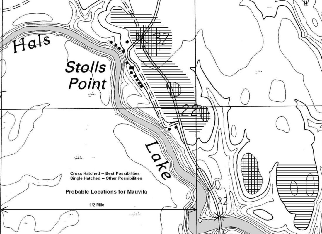
Soto continued down river to Piachi at a sharp bend in the river opposite the town of Choctaw Bluff, crossed the river, camped in a “beautiful valley” near Colton Pond, and finally to Mauvila, at or near Stolls Point.
The compelling evidence to prove Mauvila is in this location is that practically all of the other land for miles around is either low, swampy floodplain or steep hills. The land at and around Stolls Point is adequately elevated, nearly level, and perfectly fits the description of “on a plain.” It is also well suited for growing large quantities of corn.
How do we find Mauvila? Today we have technology that can find it with a great deal less labor than what was required only a decade of two ago. The first step would be to scan the appropriate areas with LIDAR, which has already discovered numerous new sites in Central America and elsewhere. Ground penetrating radar (GPR) can be used to detect the post holes of buildings and stockades.
The priority things to look for are post holes and evidence of palisades and buildings. Look for items that fit the descriptions. Large houses, buildings and palisades must be checked out. Mauvila itself had a unique palisade of logs “as thick as oxen,” gates on the east and west sides, and towers every 50 feet. Burned daub would be abundant.
Searching for artifacts would likely be unproductive. When the Spaniards finally left Mauvila, they gleaned up all of the iron and other metal to make nails and other needs. The natives later salvaged what they left behind.
Other artifacts like sherds and flakes are likely to be sparse. This would indicate that Mauvila in 1540 was a very new town, perhaps only a year or two old. One theory is that Tascalusa built and staffed this unique over-fortified complex specifically to trap and combat the Spaniards after receiving word from messengers shortly after they landed in Florida.
Another site that desperately needs serious investigation is the Pine Log Creek site (1Ba462), which has already been determined to be related to the Battle of Mauvila. The recovered “smoking guns” that prove it are two of “the ornaments for saying mass” (a brass candlestick and container) the Spaniards had lost in the fire at Mauvila—items they would have never traded or given away. This proves that the people buried there were important warriors from the battle—Tascalusa’s “principals.” Tascalusa’s son was very likely one of them. Tascalusa himself is another possibility. Because of their tall statures, they could be easily identified. A serious study of these burials should be a top priority.
There are reports that claim that the property owners of Pine Log Creek refused to let archaeologists dig and investigate the site. Although I am a strong opponent of property seizures, I would support a law that allows scientists to excavate, study and photograph special places like this over the owners’ objections, provided they return the artifacts after a reasonable time (or buy them at agreed upon prices). Furthermore, the best way to protect sites from looters is to recover and record the artifacts and let them go to museums and/or private collections.
Let’s hope we can have something to show by October 18, 2040.


Reader Comments(0)